Originally, this article was titled “Will the road to the tip of Cape York be sealed by 2020?”. However, that date has long passed and there is still plenty of dirt…and misinformation left! There still seem to be rumours that it’s all bitumen up there now, even amongst Far North Queenslanders! Let’s clear it up and explain what is really happening with the roads in Cape York.

I see plenty of questions and confusion online (and in person) regarding whether Cape York has been fully sealed yet. I also get asked often by Cairns’ locals “isn’t it all bitumen up there now?” Well, tell that to the hundreds of caravans I see pulled over on the first bad section of dirt, rethinking their choice about taking their prized rolling palace over some of the country’s worst roads – all because someone told them it was bitumen.
Admittedly I was even confused before I researched the topic. How much had been sealed? How much dirt was left? When were they promising to have it all sealed by? It’s even more confusing for non-locals, as it’s easy to assume that the Peninsula Development Road (PDR) goes all the way to the tip of Cape York. I have an updated summary for you all, after plenty of research on the Transport & Main Roads government website, Regional Development Australia website and phone calls with locals that are working on the roads.
Firstly, it’s important to understand the road names and where it all starts. The road from Cairns to Laura is fully sealed. Recently, the bitumen has extended further and further past Laura, nearly to Hann River Roadhouse now. This makes the first dirt you hit, about 30 minutes north of Laura.
The PDR itself, runs from Laura (2 hours west of Cooktown) to the Rio Tinto boundary east of Weipa…NOT to Bamaga or Pajinka (the tip). The road to Pajinka/Bamaga, branches off the PDR between Archer River and Weipa. This road continues for another 330 km, which is mostly dirt, with very few bitumen stretches in between. This is called the Bamaga Road or sometimes the Northern Peninsula Road. It might also be referred to as the Bypass Road as it goes around the Old Telegraph Track.

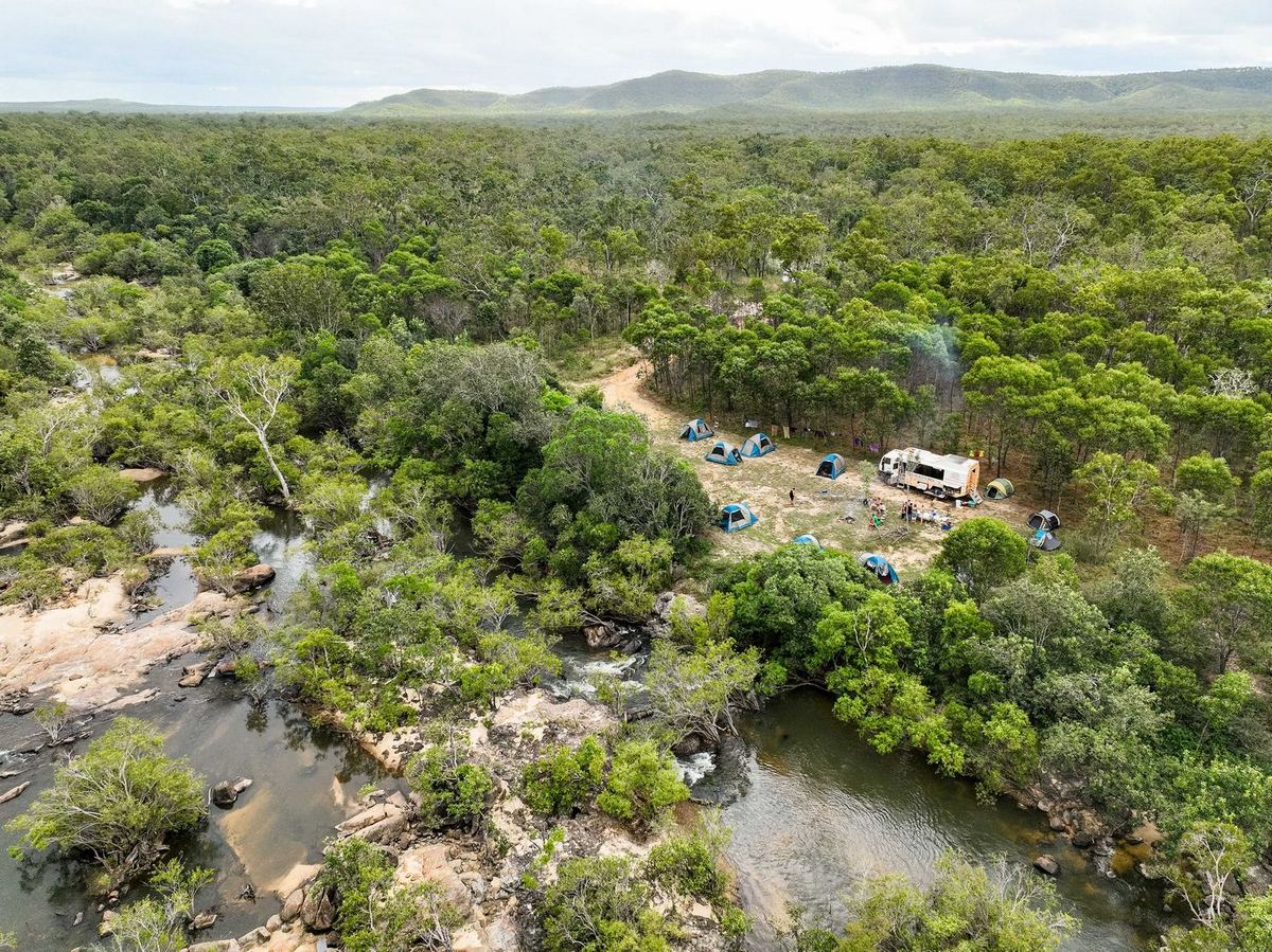
Map showing the Peninsula Development Road (PDR) and the Northern Peninsula Road. It shows the community access roads worked on by the Torres and Cape Indigenous Council Alliance (TCICA) mentioned below in the 2023 section. Note how much of the Northern Peninsula Road is currently unsealed.

According to the Transport & Main Roads website it is to improve network resilience, improve network efficiency, reduce travel time, reduce maintenance, improve safety and contribute to regional growth.
From a local and pragmatic point of view there are several other reasons. Primarily, locals in Cape York are stranded for 5 months of the year without access to shops, especially land-locked towns like Coen. The wet season cuts roads and floods rivers. Shops inflate prices due to freight costs, making simple things like flour and rice expensive, and meat prices become unfathomable. Often many shop items, especially fresh produce run out, necessitating shopping trips to Cairns. It means that emergencies or hospital visits become more easily accessible, without having to take a plane. It means that servicing and repair costs on vehicles will be reduced for locals.
The reasons above are accurate though. Safety for visitors to the region is vital. Road accidents due to road conditions or impatient driving habits are frequent in Cape York. More bitumen will reduce crashes and fatalities. It will still be wild for decades to come. Change will always happen and always be met with concern. But the far away places will still be dirt road, awaiting adventure.

Cape York is stunning, but you don’t want to go at the wrong time of year! This is a (good) section of road that locals have to use during the wet season.

The Archer River is one of the highest risk river crossings in Cape York. During the wet season it is flooded often and for long periods of time. It is uncrossable for 4WDs above 0.5m due to the power of water funneling into the area at the causeway.
The common belief was that the PDR would be FULLY sealed by 2020. The misunderstanding came from an announcement in 2014 about the “Cape York Regions Package” which included $215 million to “to progressively seal sections of the Peninsula Developmental Road between Laura and the Rio Tinto boundary, south of Weipa”. The completion date was due for late 2019.
To clarify this, it meant that by late 2019, there would just be MORE sections of bitumen in between the dirt, not that the whole PDR would be sealed, and certainly not including the Bamaga Road to the tip as well. This meant by 2020 there would be 200 km of dirt remaining on the PDR, plus the 330 km of dirt/sealed Bamaga Road. According to one of the road project managers, the goal at the time for the PDR, was that there would be no dirt sections longer than 15 km. This was to make it safer for the high volume of vehicles and provide more passing opportunities on bitumen.

This is a common sight in Cape York between June and November. Corrugations develop rapidly, however road grading can be 2-4 months apart. These are the kind of corrugations that end trips. Take care here.
The original Cape York Region Package began in the 2014-15 financial year. It was a 5-year, $276M program intending to upgrade critical infrastructure on Cape York. It was composed of 3 sub-programs
The PDR project was allocated $215.5M to seal 173 km of the 527 km between Laura & the Rio Tinto boundary of Weipa. At the end of the project 200 km of the PDR remained unsealed (as well as the 330 km Bamaga Road).
$237.5M was released for the second stage of the package, including $190M to progressively seal sections of the PDR and $47.5M to progressively seal priority sections of community access roads.
Many of the roads in Cape York come under different council areas. Cook Shire Council (CSC) covers most of Cape York, however where roads are within another council area, that council must obtain funding for road works. Aurukun, with the Aurukun Shire Council (ASC), boasts Cape York’s longest sealed road at 79 km long, completed in 2019. 73 km is within the ASC and 6 km within the CSC. There is currently 27 km remaining unsealed to the PDR, within CSC area. The ASC is lobbying the government for a final $15M to complete the last section of the 106 km road.
The Saltwater Creek bridge at Musgrave was completed in August 2022, making it the first bridge built under the package. Started in June 2021, it was intended to be completed by the wet season at the end of 2021. However, delays meant it wasn’t open until August 2022.
The second bridge in stage 2, the Archer River Bridge, was due to be complete by the end of 2022. The 225m bridge is 9 metres high, meaning it will significantly improve wet season access when complete. The Archer River is a very dangerous, fast-flowing river that locals don’t cross above 0.5m. Due to miscalculations regarding the bridge footings and bedrock, it may not be complete until 2023. Some workers think that might even be 2024, meaning 2 more wet seasons for locals. With the approach unfinished and still dirt, there are doubts whether that section of road will be usable at all during the wet season. Setbacks are not common when developing roads in outback areas of Australia, so don’t hold your breath for an all-bitumen PDR by 2030.

Map of the PDR showing finished and proposed sealed sections. Note that the PDR finishes east of Weipa where the Rio Tinto boundary starts. Source: TMR

Aerial image of the finished bridge at Saltwater Creek, Musgrave, Cape York. Source: Qld. Gov.

The Archer River bridge has hit setbacks, potentially meaning two more wet seasons without a bridge. Photo: Cape York Weekly, Source: Australian Rural & Regional News

A vehicle stranded north of the Archer River in January, 2022. Travellers attempted driving to Cape York in April, 2022 and were cut off on the north side by high water. A helicopter had to drop the vehicles food and supplies as they ran out of food.
I think this is the real question now…will it be sealed by 2040? In the 10 years of road upgrades, ending in 2024, 228 km of sealed sections will be added to the PDR, leaving 145 km of dirt remaining. Councils will then await the next funding announcement to start making plans for the rest of the PDR. Given that it has taken 10 years to do 228 km, it may take another 6 years after 2024 to complete the remaining 145 km of dirt on the PDR. That takes us to 2030.
It will take a very long time to complete the remaining 330 km of Bamaga Road. This region is even more remote with more logistical and labour challenges than further south. If the decision was made to do it, I would guess another 10-15 years after 2030. I do know that the dirt sections between Bramwell Junction and Bamaga are some of the worst on the Cape and they certainly need some work! If only it were graded more often!

The long winding section of road that goes through the Heathlands on the Northern Peninsula Road is in terrible condition for much of the dry season.
Well, those that tow 4WD caravans can still do it as many have done before. It’ll be rough and slow, but at least there will be more bitumen. I highly recommend against it, after seeing hundreds of caravans rolled, broken and on tow trucks over the years. Opt to take the swag for a couple of weeks and leave the van behind further south. You’ll save a LOT of money. See why in the intro of this article ‘Best Cape York Tours 2023’ and in ‘All Your Cape York Questions Answered’.
You’d certainly be VERY game to take a motorhome all the way up! Some locals drive their 2WD’s down to Cairns, but not often! And not without substantial risk of damage, but it is possible.
An important note to consider is that whilst the PDR may be eventually sealed, the side tracks and most roads in National Parks are still dirt. And that’s largely what makes it the outback. That difficult, challenging and arduous outback that we all love and cherish. The one we seek to feel adventurous and get a taste of what pioneering must’ve once been like. Historically, Cape York was Australia’s last frontier, the last place explored by early settlers. To this day, it remains our last frontier.
Finally, if you’d like some often overlooked & very basic tips on driving on dirt roads (anywhere) and staying safe, see our post here: How to Drive on Dirt Roads in Cape York. I think you’d be surprised what the #1 tip is!
I hope this has been helpful! If you have any questions, feel free to contact us via email or phone. We’re always happy to help! If you found this helpful, leave a comment and let us know what you think, and sign up to our blog mailing list (by clicking here). We post some great stories and media on Facebook & Instagram too, and it’s worth a look!

Sadly, we see many crashes every year. Luckily the vehicle didn’t roll in this case, only the caravan did.

High volumes of traffic on the road mean lots of white outs from dust. These can be high risk when you can’t see what is coming.
, Cape York")
Aerial image of the narrow Overland Telegraph Track (OTT) in contrast to the wide Peninsula Development Road (PDR).
, Cape York")
For a taste of what is included in a 15-day Cape York tour, or for inspiration, check out our itinerary by clicking the image below.


I’m a traffic controller where do I apply for when works underway
Hi Sylvia. I’m not sure. Perhaps try calling the Cook Shire Council or RoadTek 🙂
Hi Rossy, thanks for current info. Have driven OTL since 1970 in HD Holden. Have dome pics you may be interested in. Can drip feed them to you by email or mms.
G’day Ian! That’d be AMAZING mate! Would love to see them! Send them through to our email address. You can find it in the top bar of the page 🙂 Thanks a million.
Excellent article. Thank you very much. I await the next funding package with interest.
Thanks David! The next funding package is out and works have started 🙂
Thanks for the article – just the info I was looking for!
One question, in late December, would the tip still be likely cut off due to the weather if I’m skipping the OTT and taking Bamaga Road instead?
Thanks!
Hi Eugene,
Cape York will be VERY hot in December and it’s also very risky going that late as early storms can make the road a mess or cut the roads off with high rivers. It’s unlikely, but December isn’t an ideal time to do Cape York unfortunately. Camping won’t be pleasant due to the heat, sweating in your tent at night isn’t great fun and many camp grounds and other providers are likely to be shut.
Even if the PDR is completely sealed every causeway needs to have either pipes or box culverts placed in them to eliminate flood water during the wet season because u can’t cross them because they are flooded.
Waiting desperately to go back to the tip and experience all there is to offer along the way…however hubby says that won’t happen again for us until the road is sealed….all the way.
Hi,
I have read something that i need some confirmation on. Doing my planning to make sure we know what we are doing and what we need.
Planning to drive to the tip, next week, vehicle is a 2015 Jeep Grand Cherokee, no lift fitted.
I read that the road from to Bamaga, the road is only for vehicles that high lift kit fitted.
Can you confirm this please
Geoff
Hi Geoff,
I’m not particularly familiar with that vehicle but have seen it around. There is a ‘bypass’ highway around the Telegraph track. This is all dirt, but can at times have bad corrugations. Clearance isn’t super necessary on this road, but it helpful for the corrugations. I would say that suggestion for a lift kit is more so for the Telegraph Track. Check the HEMA map and you’ll see the highway around the OTT.
Cheers,
Rossy.
Rossy,
Hi I was very fortunate to do the trip to the tip way back in the late 80s in a Toyota Troopcarrier and because I was working for Crossland Toyota in Cairns, the vehicle I took was a company demo. At that time I was a hard working fleet salesman and amazingly was the number one Toyota salesperson in Australia. My brother came with me and we had a fantastic time but coming home I tried to cross some flooded road just out of Bamaga. I walked across the flooded part and the water was just up to my knees so I got back into the troopie and away we went. Unfortunately I had moved a little to the right and the vehicle dropped into a deep hole and without a snorkel it sucked in a good gulp of water. That was as far as we were going and slowly there were lots of people backing up behind me and that made my embarrassment even worse. There were quite a few people that I knew so we were helped to get out of the bog and got the engine firing but loads of smoke due to bent conrods etc. we eventually got the vehicle back to Bamaga and we flew home but said vehicle came back by barge. Two weeks after we got back to Cairns and everything inside was covered in slimy green stuff. At least we saw what we wanted to see on the way up and more whilst up there. On my bar in my home I have the piston with the bent conrod mounted on timber with a plaque that says, “Swamprat” ha ha